
NAGANO ADVENTURES
Guided & Self-Guided Hiking, Trail Running & Fastpacking Tours in Japan
Specializing in the Shionomichi (Salt Road) & Japanese Alps

SHIONOMICHI
Japan's Ancient Salt Road
OVERVIEW

The Shionomichi is an ancient 120km trail connecting Itoigawa on the Sea of Japan with the inland castle town of Matsumoto via rugged mountain passes, small countryside hamlets, and scenic towns at the base of the Japanese Alps. Shionomichi literally means "Salt Road" and summarizes the route's purpose as the main avenue used for transporting vital salt to landlocked Nagano Prefecture. Despite being on par with Japan's other major historic long trails like the Nakasendo and Kumano Kodo - it's one of the country's best-kept secrets, primarily because little to no information on the route exists in English. Yet what it lacks in fanfare, it more than makes up for with scenery, history, and rural charm. In fact, the absence of tourists is precisely what sets it apart from other great trails: It provides visitors with an unspoiled glimpse into authentic Japanese countryside and plenty of chances to engage with the communities along the way.
Click on the button below to watch the full 25-minute version on the YouTube channel of our sister site hikeandbikejapan.com
PHOTO GALLERY


HISTORICAL INFO
Japan's Three Major Historic Trails: Kumano Kodo, Nakasendo, & Shionomichi
For thousands of years, before the advent of motorized transportation, Japan was crisscrossed with an incredible network of footpaths of varying lengths and purposes. A handful of these trails still survive today, though most have been reduced to shells of their former glory, broken up by urbanization and widespread development. A few of those with wonderfully preserved sections, photogenic surroundings, a clear and engaging history, and/or a dash of clever marketing have even made their way onto the world travel radar. Chief amongst them are the Kumano Kodo - the ancient pilgrimage route through the forests and mountains of the Kii Peninsula, and the Nakasendo - the inland "highway" utilized by politicians and dignitaries traveling back and forth between the ancient power centers of Edo (Tokyo) and Kyoto. These are no doubt the best remaining examples of Japan's top religious and political routes with a compelling story and scenery to match, but there is another separate, extremely important type of road that played an equally vital role in ancient Japan - the commercial trade route. And the best and most fascinating example of such a path still in existence here today is without a doubt the Shionomichi, or literally the "Salt Road" in English.
The Prevalance, Purpose, & Importance of Salt Roads
For thousands of years, salt was an indispensable commodity vital for the preparation, preservation, and transportation of food. Access to salt was essential for civilizations to survive, and salt roads were used around the globe to bring it to regions that lacked it. Japan's only viable source for salt was from the sea, and two primary salt roads were used to carry the crystalline mineral inland: the Chikuni Kaido starting at the Sea of Japan, and the Sanshu Kaido starting at the opposing Pacific Ocean coastline. Of those, the Chikuni Kaido is the best preserved and most historically important, and the one that's synonymous with the terms Shionomichi and Salt Road today.
Japan's Premier Salt Road: The Chikuni Kaido
The Chikuni Kaido was in use from the late Middle Ages up until the end of the 19th century. It originated on the Sea of Japan's coast in the area of modern-day Itoigawa city and reached its terminus in the inland plain castle town of Matsumoto some 120 kilometers later. Today it is possible to cover the Chikuni Kaido from start to finish on a combination of paved roads and quiet paths that follow or closely parallel the original route. It’s an epic journey that presents plentiful opportunities to enjoy gorgeous scenery, capture memorable photos, interact with locals, observe deeply-held customs and traditions, encounter wildlife, soak in hot springs, sample regional foods, and see a side of Japan that goes unseen by all too many.
FREQUENTLY ASKED QUESTIONS
What to Expect on the Shionomichi
The Shionomichi is a wonderful trail that has much to offer, but unfortunately, with so little English information currently available online, it can be hard to know what to expect, and nearly impossible to plan a trip and navigate the route on your own. To provide a little more clarity on what to expect, I'll try and answer some of the questions I'm frequently asked about the Salt Road:
Q. What is the trail like?
A. The Shionomichi is best thought of as a historic trail, not a remote nature trail. While there are some beautiful forested sections, which you've no doubt seen photos of if you're reading this, approximately 70% (84 kilometers) of the entire 120-kilometer distance travels on paved roads. The paved portions of the walk are still very scenic and pleasant, and take place on quiet narrow lanes with little vehicular traffic the vast majority of the time. Unlike the Nakasendo, processions of feudal lords and high-ranking officials did not regularly pass along the route, nor were pilgrims using it to link large, important temples or shrines like on the Kumano Kodo. Instead, the Shionomichi was a road for the common people... and still is. The areas it travels through provide you with the uncommon opportunity to immerse yourself in common countryside life, and to see and experience a different, deeper side of Japanese culture.
Q. Is the route marked?
A. Yes and no. The trail travels through two prefectures and seven municipalities, and there is currently no coordination between local governments, and no organization that oversees the trail from start to finish. That means there is no uniform signage like you'll find on the Nakasendo or Kumano Kodo. Itoigawa city and Otari village, at the northern end of the route, do a fair job of marking the trail, but the areas to the south do not, with markers disappearing entirely around Ikeda, roughly halfway through. The unmarked southern half travels through an increasingly urban area, and there are relatively few historically significant sites or objects overtly related to the Salt Road, so in that sense, it is less important to follow a specific path. Furthemore, general navigation is fairly straightforward here, as you only need to follow the valley south, keeping the Alps to your right.
Q. Are there any maps available?
A. As of now, there are no English Shionomichi maps available that I know of, and surprisingly few in Japanese. As such, I have produced my own set of 1:15,000-scale, A3-sized maps to assist walkers on the trail, which are included as part of the self-guided materials I offer.
Q. Is it easy to stay on course?
A. Honestly speaking, navigating the Salt Road can be tough at times, particularly because the trail is often poorly marked, or not marked at all as detailed above. Furthermore, though the Shionomichi is beginning to grow in popularity, there are still relatively few walkers, and local governments have not yet been given enough incentive to budget more for the trail. That means that the number of people working on the trail and the total man-hours devoted to it are low, and in this part of the country, where the soil is rich and the rain is frequent, fast-growing weeds can complicatie efforts to stay on course. With that said, one of my jobs aside from guiding is trail maintenance on the Shionomichi for the village of Otari, and I and my co-workers do our best to keep the trail ready for walkers. I'm also in the fortunate position of being able to cut the grass or repair damaged sections of trail in advance of my customers' walks most of the time.
To give you the best chance of success, I recommend a three-prong approach for navigating the Shionomich utilizing: (1) paper maps, (2) a smartphone, sports watch, or dedicated gps device preloaded with gpx tracks covering the sections of trail you intend to walk, and route notes that offer photos and descriptions of which way to head in areas that are known to be confusing.
Q. Is it possible to walk all the way to Matsumoto?
A. Most guided walks and group tours tend to skip the final 15 or 20 kilometers from Azumino to Matsumoto since it's the busiest and most built-up segment of the entire Shionomichi, but if your goal is to complete the trail from start to finish, it is possible. There are actually several approaches into Matsumoto via different branches of the Salt Road and one that I would recommend over the others for sure.
Q. Which direction is best to head?
A. There are a number of advantages and disadvantages of going both ways, and it really just comes down to deciding what sounds better to you after considering all the information carefully. I'll provide a brief rundown of the major reasons to go each way from my own experience and perspective:
Itoigawa to Matsumoto (North to South)
-
Shionomichi means "salt road," and this is the direction salt traveled. For that reason alone, it may be more meaningful to head in this direction.
-
The mountain passes and trails on the northern end of the trail are the most difficult, so it can be nice to get them out of the way when your legs are still fresh.
-
The actual starting point of the trail in Itoigawa is a little anti-climactic. Conversely, concluding in Matsumoto at the castle is a grand, symbolic ending point.
-
Matsumoto is a nice place to spend a day or two at the end of the walk, and can also be used as a jumping-off point for some nice day trips or overnight escapes.
Matsumoto to Itoigawa (South to North)
-
Going this way, the best trails and scenic highlights come towards the end of the walk, so in some sense, every day gets better and better.
-
The crux of the walk is the Oami mountain pass that straddles Niigata and Nagano Prefectures. The pass is easier in this direction since you climb the steep, narrow, and occasionally loose trail on the south side, instead of descending it.
-
Starting inland and finishing at the ocean means there is slightly less elevation gain overall in this direction.
Q. How hard is it?
A. There are
- How hard is it?
- How many days does it take?
- Are there places to get food & water?
- What sort of accommodations are there?
- Can I camp?
- Can we go without a guide?
Terrain & Navigation
You can find more information on how theShionomichi is not a nature trail
Food & Water
Coming soon
Facilities & Accommodation
Coming soon
Cultural Activities & Experiences
Coming soon
Guided, Self-Guided, or Unguided
Coming soon
TRAIL INFO
Name: Shionomichi (Sometimes written as Shio-no-michi or Shio no michi)
Alternative Monikers: Chikuni Kaido, Matsumoto Kaido, Itoigawa Kaido
Historical Period: Used between the Middle Ages and late 19th Century
Total Distance: Approximately 120 kilometers / 75 miles
Cumulative Elevation: Approximately 4,000 meters / 13,100 feet
Overall Road / Trail Ratio: Approximately 30% Trail / 70% Road

The trail can be roughly divided into three major sections, each with its own particular landscapes, characteristics, and appeal: the Mountain Area (Itoigawa & Otari), the Satoyama Area (Hakuba, Omachi & Ikeda) and the Urban Area (Azumino & Matsumoto).
Mountain Area
Itoigawa - The route starts near the ocean and kicks off with an extended section of paved road through the city in the direction of the mountains looming large on the horizon. After passing through Miyama Park some 3 kilometers later, the trail proceeds to jump back and forth between asphalt and gravel roads broken up by short, but beautiful, sections of trail in Itoigawa, steadily climbing higher past vast expanses of rice fields before finally settling into a long section of forested dirt trail just beyond the small but worthwhile Salt Trail Museum. You pass the stunning Shiroike pond immediately before crossing over into Nagano Prefecture via Otari’s beautiful and rugged Oami Mountain Pass (Oami Toge).
Otari - The best-preserved and most scenic nature sections are located in the small rural village of Otari, with the aforementioned Oami Pass’ deep v-shaped trail cutting through the heart of a gorgeous beech forest being the highlight of the area and possibly the whole Chikuni Kaido. The Shionomichi here perfectly showcases Otari’s satoyama (foothills) landscape by artfully weaving in and out of forested mountain paths and idyllic countryside hamlets. This portion of the Shionomichi makes you feel as if you’ve stepped back in time.
Satoyama Area
Hakuba - Just before entering the renowned snowsports mecca of Hakuba Village you’re greeted with spectacular views of the Northern Alps from Otari’s Tsugaike Kogen ski resort, and those views only get better as you walk through the valley paralleling the imposing range of nearly 3,000m peaks that dominate the western skyline from Hakuba all the way to Matsumoto. There are several sections of unpaved trail here, but for the most part, the route through Hakuba onward is characterized by long stretches of road. In addition to the incredible alpine scenery, some of the minka towards the southern end of the village are a sight to behold.
Omachi - The Shionomichi reaches beautiful Lake Aoki almost as soon as it enters Omachi. Lake Aoki is the first and largest of the “Nishina 3 Lakes” and is a popular and picturesque summer getaway destination for families offering SUP, kayaking, camping, canoeing, and more. The Chikuni Kaido hugs the western banks and proceeds under a pleasant forest canopy, skirting past Laka Naktatsuna and Lake Kizaki in quick succession. Beyond the lakes, the trail travels on pleasant paved roads past charming homes along the outskirts of Omachi.
Ikeda - This is the shortest portion of the route in terms of distance at roughly 9km and follows quiet paved roads. There are no standout must-see sights, but the verdant rice fields and immaculately manicured Japanese-style gardens surrounding well-kept traditional houses are impressive enough.
Urban Area
Azumino - The endless rice fields and picture-perfect gardens continue into Azumino, but look carefully and you'll spot something else: wasabi farms. Azumino is the number one producer of wasabi in Japan owing to its abundant spring water, and the trail takes you in close proximity to a number of small-scale family-owned farms. Sticking to the “official” trail is tough at times, but the route essentially parallels the JR train line. The Hotaka Station / Shrine area is a nice place to rest, refresh and try some local wasabi products. If you are traveling the entire route, Azumino is a good option to stop for a day to rest or do some sightseeing.
Matsumoto - The path through Matsumoto is largely unmarked, all on pavement and increasingly urban, and most people, unless determined to walk the entire trail from start to finish, choose to skip the final walk into the city, opting instead for transfer by train or taxi. Yet, modern Matsumoto still manages to retain many charming elements from its past. The Chikuni Kaido officially concludes just south of the castle at the Ushitsunagi Ishi, a stone with a large hole in it that was used to tie up pack animals for the purpose of relieving them of the loads they carried there, and a visit to the majestic Matsumoto castle at the conclusion of a walk on the Shionomichi is the perfect grand finale.
THE SHIONOMICHI x NAGANO ADVENTURES
QUALIFIED
I am a certified Shionomichi Guide and a member of several Salt Road clubs and committees for the village of Otari, as well as a licensed Guide-Interpreter for the city of Azumino; the only non-Japanese person to hold those distinctions. I am also a professional-level Wilderness First Responder.
KNOWLEDGEABLE
Other guides might be able to keep you on course and give you general historical information about the Salt Road, but I can fill you in on the firsthand stories, local legends, and fascinating details that you won't get anywhere else; all learned through countless hours on the trail with area residents, local guides, and leading Salt Road experts.
LOCAL
I don't just guide the Salt Road: I live on, work on (trail maintenance), train on, commute on, and have relationships with, and the trust of, the people and communities along the Salt Road. That is something no other tour company or English-speaking guide can offer, and leads to a deeper, more rewarding trip.
PASSIONATE
I truly believe that I am the best and most qualified English-speaking guide available for tours on the Shionomichi, but even more certain that no one is more passionate about the route and the areas through which it passes. I would love the opportunity to share the trail, my local area, and some of that enthusiasm with you!


THE SHIONOMICHI BY SEASON
Japan's four distinct seasons are on full display, almost to the point of exaggeration, across the 120 kilometers of the Shionomichi. As a whole, the trail should only be considered passable from start to finish between the snow-free months of May and November, though some sections can be enjoyed on snowshoes during the winter snow season. Each season has something to offer, but I would generally say the most comfortable conditions and most interesting times to walk are spring and fall.
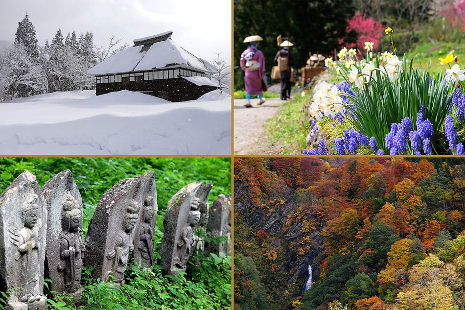
Seasonal Highlights
Mid-April - In average years there is still plenty of snow in the mountainous areas along the northernmost part of the trail in Itoigawa city and Otari village, but it can be a pleasant time to stroll along the southern half and an excellent opportunity to catch the cherry blossoms in full bloom around Matsumoto Castle.
Early May - The Salt Road Festival takes place over several consecutive days during the Golden Week holiday period, beginning in Itoigawa on May 2nd, followed by Otari on the 3rd, Hakuba on the 4th, and Omachi on the 5th. Each municipality has its own unique draw, but traditional costumes, musical performances, free food giveaways, and processions along a portion of the trail are standard. If you only have one day, Otari's version is the can't-miss highlight of them all.
Early June - By now the snow has melted completely from the trail and the vibrant greens of spring dominate the landscape. Daylight hours are almost at their zenith and the rainy season has yet to set in. Most areas will have finished planting their rice fields, and various flowers are still in bloom throughout the mountains and the population centers. Daytime temperatures are creeping higher, but still significantly lower than the summer peak, and generally with less humidity.
August to September - Summer in Japan can be terribly hot and humid, and that often holds true for August and September on the Shionomichi as well. It doesn't necessarily mean that it's a bad time to walk, and mornings and evenings offer some relief, but those planning a trip during this period should be prepared to deal with the heat... and bugs. On the other hand, summer is an exciting time with plenty of festivals and events happening across the country and in the areas through which the Salt Road passes. If you time your visit right, you may be able to observe or even take part in some!
Early to Mid November - Autumn leaves reach their colorful crescendo on different parts of the trail at different times, but the first half of November is usually when the fiery fall foliage is at its best in and around the scenic sections of trail in Otari. It can also be a good time to appreciate the contrast of vibrant reds and yellows in the foothills with freshly fallen snow covering the tops of the surrounding mountains.
MAIN ACTIVITIES

HIKING

FASTPACKING

(TRAIL)
RUNNING

SNOWSHOEING

CYCLING
OPTIONAL ACTIVITIES

Museums
A journey along the Salt Road is rewarding enough, but if you have the time and energy, there are numerous experiences and activities along the way that can be added to the standard itinerary and provide even more opportunities to engage with the area's impressive nature and fascinating culture.
LOCATION & ACCESS


The Shionomichi travels through Japan's Chubu Region, specifically Niigata and Nagano Prefectures. It starts at the sea in the city of Itoigawa and concludes near Matsumoto Castle. Itoigawa is served by the Hokuriku Shinkansen, a bullet train that provides easy access from major cities and nearby tourist areas in under 4 hours, while Matsumoto can be reached within 3 hours or less by limited express trains, highway buses or various other means of transportation.
To/From ITOIGAWA
Tokyo
2 hours
(Hokuriku Shinkansen)
Osaka
4 hours
(Thunderbird Ltd. Express
& Hokuriku Shinkansen)
Nagoya
3 hours 45 minutes
(Shinano Ltd. Express & Hokuriku Shinkansen)
Nagano/Kanazawa
40 -50 minutes
(Hokuriku Shinkansen)
To/From MATSUMOTO
Tokyo
2 hours 30 minutes
(Azusa Ltd. Express)
Osaka
3 hours
(Tokaido Shinkansen &
Shinano Ltd. Express)
Nagoya
2 hours
(Shinano Ltd. Express)
Takayama
2 hours 30 minutes
(Highway Bus)