
Shinetsu Mountain Madness - Day 1
- Paul

- Jul 14, 2020
- 4 min read
Shinetsu (信越) refers to the region of central Japan comprised of Nagano and Niigata prefectures. The term is derived from a combination of the characters for the names of each area during the feudal period, when Nagano was known as Shinshu (信州) and Niigata as Echigo (越後). While Nagano is well known for its mountainous landscapes, Niigata is most often associated with the ocean due to its extensive coastline along the Sea of Japan. But in reality, it too is blessed with an abundance of impressive peaks and demanding trails. In fact, the Shinetsu Five Mountains Trail race (信越五岳) is one of Japan's premier long-distance mountain ultras, with both a 110km and 100 mile option. While our home is located in Nagano, we are a mere 11km from the Niigata prefectural border, and a range of trails in both regions are easily accessible.

In late June, two good friends and fellow trail junkies came out to Otari for a 3-day visit from the greater Tokyo area. Despite being rainy season, the forecast looked somewhat decent and we quickly got to work cramming our schedule with as much trail time as possible. Because the local train connections direct to our rural area are often inefficient, I agreed to pick the guys up from Nagano station early on Friday morning to maximize our opportunities for adventure. I made the one hour drive in constant rain, but by the time I met up with the guys, the rain had mostly stopped and it seemed we'd have a several-hour window without precipitation. We had multiple options lined up for a mid-distance trail run and ultimately decided on sticking with our plan A - an 18km "infinity loop" of the ancient complex volcano, Mt. Kurohime (2,053 m). We made the short scenic drive to the Togakushi area, just north of Nagano city, and were on the trail by 9 a.m.


Heavy rainfall the night before and in the days leading up to our run that morning had turned the trails muddy and slick, but the rain was still holding off for the most part as we set out. We made good progress early on, before a missed turn and a short backtrack to our intended trail cost us 10 to 15 minutes. We could have gone either way and made it to our destination, but with the uncertainty surrounding the weather and in an effort to maximize the runnability of the return leg - we wanted to get the steeper and more exposed climb to the summit done as early as possible, and save the cruise-y forested bits for the latter half of the run.

As we continued climbing we were met with intermittent bouts of light rain, but they only added to the soothing sounds and overall atmosphere of the surrounding forest. We hit the summit ridge in fog and thick clouds that obscured the scenic views, but were spared the rain above the tree line. We stopped briefly at the summit for a group photo and some snacks, but got back on the trail and began to loop around behind the summit, heading in the direction of the area closest to the caldera - a landscape now dominated by a series of picturesque ponds and marshes.

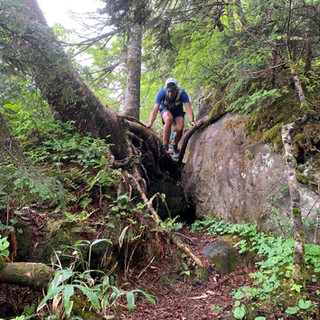
None of us had been on that section of trail, but the elevation profile made it look like a gentle and fantastically-runnable descent. The reality however, was very different, with thick, twisted roots and large wet rocks consistently slowing our pace and restricting our runs to short spurts on the rare obstacle-free stretches.


That's not to say it wasn't enjoyable. Traveling through a variety of landscapes on a variety of trails is a great way to keep things interesting and exciting. This day even more so, as the weather largely restricted our views to what was right in front of us. Even with our wrong-turn tacked on we finished the roughly 9 hours of map time in less than 4 hours. The 18 kilometer loop featured just over 1,000 meters of elevation gain and traveled through some fascinating terrain. The distance and elevation were just about perfect for a quick morning activity, and on a clear day the views should be quite impressive.


We ended our run with a relaxing dip in a beautiful local onsen (hot spring bath), and topped it all off with a tasty meal of Togakushi's speciality - soba noodles. In the end, we chose our route and timed our run perfectly: while we enjoyed our meal, the skies unleashed a fierce torrent of rain outside that would have further flooded the trails and significantly dampened our spirits... and our gear. Since this was just the easy prelude to our upcoming 2-day adventure, we made the drive back to our home in Otari, prepped our kit and got to bed. Little did we know just how crazy the next two days would be.

TO BE CONTINUED...


Comments